


As the month of January 2019 progressed, there were more beautiful mornings, like the ones below...


Some mornings were very foggy and dreamy.....


2019 brought me a refreshing change to my routine..For the past few weeks, I have been walking a new trail almost daily, some days 3 1/2 miles, other days nearly 5 miles depending on the weather / how I feel.. This trail in Morgan's Point is part of a very quaint, old community which neighbors mine in La Porte....Morgan's Point is the Home of the Yellow Rose of Texas.. I will give you a little history below..
_________________________________________________________________________________
_________________________________________________________________________________
History[edit]

The area was first settled in 1822 by Nicholas Rightor, a surveyor commissioned by Stephen F. Austin to explore and survey the areas between the Brazos and Lavaca rivers.[4] He soon sold the property to Johnson Calhoun Hunter, and it subsequently was bought by Joseph C. Clopper, who used the property to grow orange and lemon trees. The property was finally sold to James Morgan in 1834, who established the short-lived colony of New Washington. Morgan had helped supply the Texian army during the Texas Revolution and was given the rank of colonel. The settlement was destroyed by the Mexican army during the Texas Revolution. A legend surfaced much later surrounding a mulatto woman named Emily West.[5] She became an indentured servant (but not a slave) of Morgan and, according to legend, used her beauty to occupy Mexican General Santa Anna, thereby facilitating his capture by the Texan army, thus ending the revolutionary war. Historians differ on the degree of truth of this legend.
The area began to redevelop as the Houston Ship Channel was dredged near the area in the later 19th century. The community grew around traffic crossing the ship channel to and from Goose Creek (now Baytown). Ferry service would eventually become established. The Morgan Point Ferry operated until the mid 20th century.
Following the start of the Texas oil boom in 1901 Galveston Bay became an attractive summer destination for the wealthy from Houston and nearby areas.[6] Plots along Bayridge Road were sold for the construction of summer homes, including the famed Sterling Mansion, a former governor's residence that is now a landmark (not to be confused with the mansion in Houston).[7] During the 1920s and '30s the shoreline between Morgan's Point and Sylvan Beach came to be known as the Texas "Gold Coast", a playground for the rich.[8]
As the surrounding communities of La Porte and Pasadena grew, interest in the area as a summer haven diminished. Morgan's Point was finally incorporated in 1949, and a small community remained. Some of the original 19th century buildings have remained, as well as early 20th century homes.[4]
The area received a major economic boost in 1977 with the opening of the Barbours Cut shipping terminal, operated by the Port of HoustonAuthority. However, in building Barbours Cut, the Port of Houston used its power of eminent domain to evict residents from nearly one third of the community's homes.[9] Still the terminal almost instantly became the Houston area's most important shipping point and became the centerpiece of the economy activity at Morgan's Point.[10]
Geography[edit]

Morgan's Point is located in southeastern Harris County at 29°40′35″N 94°59′58″W (29.676368, -94.999580).[11] It is bordered to the north and west by the city of La Porte, and to the southeast by Galveston Bay. The city limits extend out into Galveston Bay, within Chambers County. It is 27 miles (43 km) east of the center of Houston.
According to the United States Census Bureau, the city has a total area of 1.7 square miles (4.5 km2), of which 1.5 square miles (4.0 km2) are land and 0.2 square miles (0.5 km2), or 11.12%, are water.[3]
Demographics[edit]
| Historical population | |||
|---|---|---|---|
| Census | Pop. | %± | |
| 1950 | 656 | — | |
| 1960 | 560 | −14.6% | |
| 1970 | 593 | 5.9% | |
| 1980 | 428 | −27.8% | |
| 1990 | 341 | −20.3% | |
| 2000 | 336 | −1.5% | |
| 2010 | 339 | 0.9% | |
| Est. 2016 | 351 | [12] | 3.5% |
| U.S. Decennial Census[13] | |||
As of the census[1] of 2000, there were 336 people, 111 households, and 85 families residing in the city. The population density was 208.1 people per square mile (80.6/km²). There were 143 housing units at an average density of 88.6 per square mile (34.3/km²). The racial makeup of the city was 88.69% White, 4.46% African American, 0.89% Native American, 4.46% from other races, and 1.49% from two or more races. Hispanic or Latino of any race were 12.80% of the population.
There were 111 households out of which 19.8% had children under the age of 18 living with them, 64.9% were married couples living together, 9.0% had a female householder with no husband present, and 23.4% were non-families. 23.4% of all households were made up of individuals and 9.9% had someone living alone who was 65 years of age or older. The average household size was 2.32 and the average family size was 2.64.
In the city, the population was spread out with 32.4% under the age of 18, 5.7% from 18 to 24, 19.9% from 25 to 44, 28.0% from 45 to 64, and 14.0% who were 65 years of age or older. The median age was 38 years. For every 100 females, there were 114.0 males. For every 100 females age 18 and over, there were 102.7 males.
The median income for a household in the city was $57,917, and the median income for a family was $71,458. Males had a median income of $40,313 versus $30,625 for females. The per capita income for the city was $32,446. None of the families and 2.2% of the population were living below the poverty line, including no under eighteens and none of those over 64.
__________________________________________________________________________________________________________________________________________________________________
My walking trail starts at Park Street which begins at the Sylvan Beach parking lot...Sylvan Beach is where I snapped the above shots of sunrises on different mornings this month..My route then follows Bayridge Street and ends just before the channel - Morgan's point.. Sometimes I take a left turn by Vinson's crossing , where I take in a view of the busy shipping Terminal, Barbour's Cut.. Then I turn around and walk back to my car at Sylvan Beach..
I enjoy seeing the old homes I pass with each footstep..When I walk this trail, I feel like I am stepping back into a bygone era ..This area is very quiet and peaceful, in spite of ongoing renovations on a few homes..
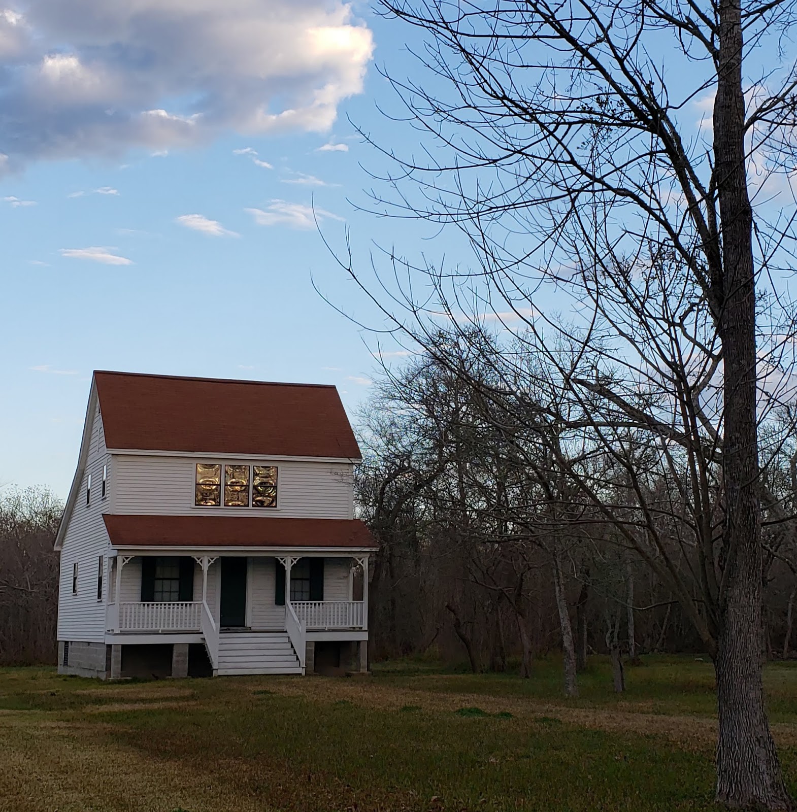
I spotted one home under construction that was never completed...Very cute shell of a house on a nice piece of land...I dream of being able to buy this land..I would love to finish this home and live there with my Simon...In reality, this dream would be too far fetched for me to realize and live ..Ohhhh, well......

Above is a real estate listing for the house I dream of buying for myself and Simon..Below is how I see this very cute shell of a house, as I walk by..
These historical homes along my path also intrigue me......


One side of my route overlooks the bay..

Even the sidewalks under my feet have some personality..

There is also a tiny hiking /biking trail tucked in this little community..


Needless to say, I have been enjoying these winter months immensely!
May your 2019 be full of love, laughter, fun, joy and hope!!!
Such great images to fill the heart as we begin 2019. I'm smiling!
ReplyDeleteI really enjoyed all these photographs. I especially liked the one of the gate.
ReplyDelete